
NSF Funds UCI Project to Study Post-wildfire Mudslides and Flooding
Interdisciplinary researchers will examine infrastructure and public preparedness

Aug. 19, 2021 - Wildfires in California can cause immediate, catastrophic damage, but the risk to communities often persists long after the flames have been doused. Heavy rainfall may subject fire-ravaged regions to torrents of mud and debris that can inundate or overtop the state’s existing flood-control basins, channels and other protections.
With $670,000 in funding from the National Science Foundation, an interdisciplinary team at UCI is launching a new three-year project to study hazards facing people living in affected areas.
“Our initiative has two main components,” said principal investigator Brett Sanders, UCI professor of civil & environmental engineering. “First, we want to understand the true flood hazards facing communities below burn areas – accounting for the fact that infrastructure may get clogged and no longer perform as designed. Then we will measure the level of awareness and preparedness of communities to the possibility of fire-and flood-born disasters.”
The expansion of urban development across California, especially below mountain wildlands, has resulted in more people being put at risk of post-fire flooding, according to co-principal investigator Doug Houston, UCI associate professor of urban planning & public policy. He added that understanding public awareness of this hazard is crucial given the increasing population of Californians living in impacted areas.
“Previous research shows that people can get a false sense of safety from infrastructure such as debris basins and flood channels,” he said. “Many living along the wildland-urban interface don’t realize existing flood-controls may not be sufficient to contain extreme post-wildfire mudslides and flooding. We will map at-risk areas and survey residents about their awareness to help enhance risk communication and reduce fatalities in the future.”
Wildfire frequency and intensity have increased over the past decade in the southwestern U.S. and many other parts of the world with semi-arid and Mediterranean climates. With the trees and brush that hold soil in place having been eliminated by fire, the ground becomes highly vulnerable to mud and debris flows from intense precipitation, creating heightened flood risk for communities below burned areas for several years after the initial incident, according to Sanders.
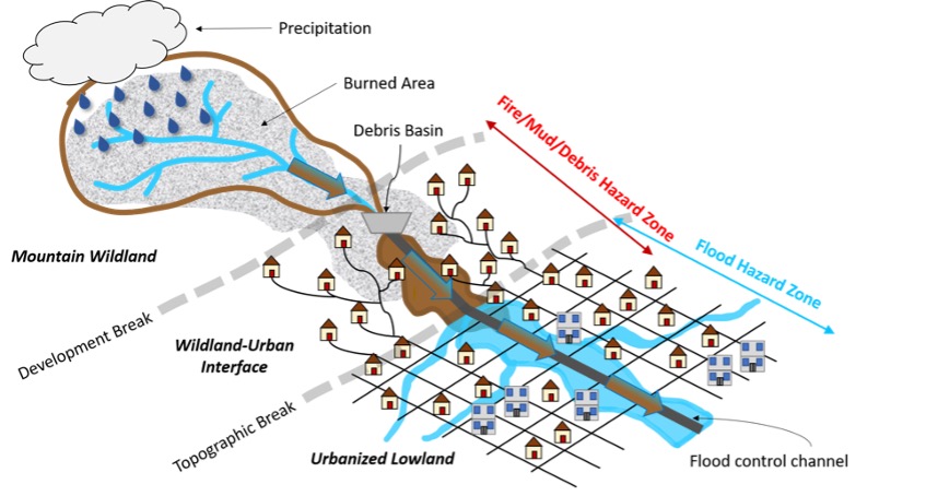
“Communities are generally protected from flooding, mud and debris by two types of flood management infrastructure: debris basins and flood control channels,” Sanders said. “The debris basins are designed to catch the solids at the foot of mountain catchments, and the channels are designed to move floodwater and fine sediment downstream quickly past developed areas.”
Sanders said that while there has been a lot of important work to estimate the growing potential for mud and debris flows that follow winter storms in California, there has not been enough study of how well communities are protected by infrastructure and what can be done to enhance public safety.
His team has already been at work developing new models to estimate how well infrastructure can withstand compounding hazards of successive fire and flooding events. Ariane Jong, a graduate student in the Department of Civil & Environmental Engineering involved in model development and testing, has found that by considering the possibility of infrastructure clogging over several successive storm events, the risks to communities may be several times higher compared to analysis on a single event basis.
Representatives from Riverside County Flood Control agency will collaborate with the UCI researchers on this project.
– Brian Bell / UCI